Focus+context metro map layout and annotation
Published by Issei FUJISHIRO on
Hsiang-Yun Wu
in Proceedings of Spring Conference on Computer Graphics (SCCG2016), Bratislava (Slovakia), April 2016
[doi: 10.1145/2948628.2948642]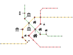
An annotated metro map, which is a graphic representation that abstracts the transportation network and provides additional details of a city, can be hardly drawn due to the landmark density around the city center. A focus+context illustrated map is therefore commonly used to provide detailed information around a focus region while preserving the context area, so that map readers can still keep the mental image of a city. Nonetheless, conventional techniques do not sufficiently keep the layout octiinearity over navigation process, especially large deformation is required when they are significant landmarks around center stations. This paper introduces focus+context annotated metro maps, a design of emphasizing focus regions by embedding landmark icons around the stations together with aesthetically aligning metro lines and label leaders in an octilinear fashion. Our idea is to employ the conventional fisheye technique when considering appropriate edge lengths in a focus region, and to generate sufficient space around the labeled stations by introducing a relative neighborhood graph for deformation purposes. This is accomplished by introducing appropriate design conditions into a linear program so that we can constrain the positions of stations and labels while preserving the octilinearty within both focus and context regions. The optimization problem is then solved in a least square sense. We also provide a user interface for customizing maps through intervention and present several design examples to demonstrate the effectiveness of the approach.
Publication page in 2016 is here

0 Comments